
Enlarging the boundaries
06/02/16 17:51
So, after much thought, I have decided to redefine this study a bit.
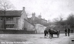
It started off as a study of the 12 or so (the exact number has varied over time) houses making up the Springhill area of Higher Cloughfold. That has always been interpreted fairly loosely, so for example John Ashworth's interests in collieries led me to look as some aspects of the mines he owned and the mining industry in general. Essentially, if it could be linked to a Springhill resident, it went in.
A strict interpretation did leave a number of interesting subjects outside this definition. These include the 325 yr old Baptist Church just across Edge Lane from Springhill, the 625 yr old Friends' Burial Ground and history of the early Quakers at Chapel Hill, the impact of the railway, the history of the Rossendale Union Gas Board on Bacup Road, the school at Choughfold…
So for some time I have been wondering about extending the boundary. The main theme will still be the 12 or so houses in the Springhill area but extending it will allow me to look as some of these areas in more depth.
So far so good, but how to choose the new boundaries?
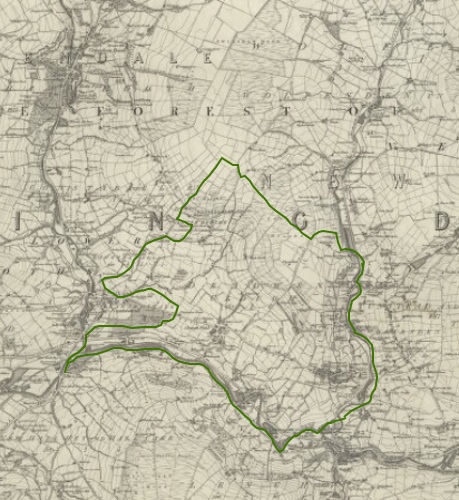
i have decided therefore to go with the boundaries of the old vaccary of Deadwenclough for a number of reasons:
I had earlier toyed with a boundary of 1km radius from Springhill. This largely overlaps with Deadwenclough, and it makes sense to use the area for which set boundaries exits and which is recognised in records.
I spent an enjoyable but rather muddy couple of afternoons walking the boundaries (or as close as feasible without trespass) and getting a feel for the new patch. It took a bit of detective work with an 1840 description together with old and modern maps and ariel photography to complete it.
This means that a fair number of the census returns, trades directories etc will have to be redone. That will take time.
Anyway, here it is:
It started off as a study of the 12 or so (the exact number has varied over time) houses making up the Springhill area of Higher Cloughfold. That has always been interpreted fairly loosely, so for example John Ashworth's interests in collieries led me to look as some aspects of the mines he owned and the mining industry in general. Essentially, if it could be linked to a Springhill resident, it went in.
A strict interpretation did leave a number of interesting subjects outside this definition. These include the 325 yr old Baptist Church just across Edge Lane from Springhill, the 625 yr old Friends' Burial Ground and history of the early Quakers at Chapel Hill, the impact of the railway, the history of the Rossendale Union Gas Board on Bacup Road, the school at Choughfold…
So for some time I have been wondering about extending the boundary. The main theme will still be the 12 or so houses in the Springhill area but extending it will allow me to look as some of these areas in more depth.
So far so good, but how to choose the new boundaries?
- The ancient parish of Whalley is huge. The modern parish of Newchurch St Nicholas is manageable but Springhill hasn't always remained within this parish and the parish boundaries have change markedly and repeatedly over the last 200 years as daughter churches formed then reunited.
- The current civil administrative area of Rossendale is too large and has only existed since 1974. The old one, Ratwenstall, itself only existed since the late C19. Whilst this makes sense geographically it includes areas of little direct relevance to Springhill, for example villages of Goodshaw and Crawshawbooth over the moor.
- The earlier township of Newchurch was also large and Springhill was at its extreme west end. There is a large area to the east of Newchurch village that is within the old township but of little relevance to Springhill.
i have decided therefore to go with the boundaries of the old vaccary of Deadwenclough for a number of reasons:
- It is pretty much centred on Springhill and therefore would be the immediate community historically
- It is the administrative area in use as the land emerged from forest law in 1507 and so court rolls and other documents dating from the earlier part of Rossendale's history refer to it.
- I have already, for this reason, extracted material for 'Deadwenclough' if the records are to old or vague to permit more specific localisation.
- Parish and other records still referred to Deadwenclough, albeit not consistently, until at least the mid C19.
- It is small enough to be feasible
- It contains a reasonable range of additional material to study: churches, schools, mills, utilities, quarrying, retail, public houses and the like.
- It contains most of the material included in my current 'one square on the map' page, which will remain.
I had earlier toyed with a boundary of 1km radius from Springhill. This largely overlaps with Deadwenclough, and it makes sense to use the area for which set boundaries exits and which is recognised in records.
I spent an enjoyable but rather muddy couple of afternoons walking the boundaries (or as close as feasible without trespass) and getting a feel for the new patch. It took a bit of detective work with an 1840 description together with old and modern maps and ariel photography to complete it.
This means that a fair number of the census returns, trades directories etc will have to be redone. That will take time.
Anyway, here it is: